Red Mountain Mining Ltd (ASX:RMX) High-Grade Antimony Results at Armidale Confirm Potential For a Major Antimony-Gold System
Price Sensitive Announcement $
Highlights:
· Targeted soil sampling program at Oaky Creek South returns a series of high-grade assays with a peak value of 1,200 ppm Antimony, with 13 samples exceeding 100ppm Antimony across the whole program
· A significant auger soil result of 1.36% Sb, over 10x the next highest recorded value was also recorded at Oaky Creek South workings, the sample returned the highest gold value of 14ppb.
· A coherent 200m long northeast-striking Sb-As anomaly has been identified which remains open to the northeast (Figure 4)
· A second grid, 300m north of the Oaky Creek South workings returned strong anomalous arsenic, a path-finder for gold, with a maximum value of 259ppm As, which remains open to the northwest towards the Main Grid, to the southwest, and south towards the historical Antimony workings
· Red Mountain has now received all assay results from the Oaky Creek South sampling campaign. The highly encouraging soils results, alongside the previously reported high-grade Antimony rock mineralisation of up to 39.3% Sb, has prompted immediate planning for the field team to launch an exploration program in December to define specific drill targets:
o RMX will expand the grid at Oaky Creek South to cover the area between the historical workings and the Main Grid, testing the NE extension of the exceptionally high anomaly
o A strong 1km-long Antimony soil anomaly extending SSE from Oaky Creek North will also be tested by auger sampling, prior to expected drilling
o Soil sampling results received at East Hills will also be further explored as the results define NNW-trending soil Antimony anomalies, with a peak value of 104ppm Sb
· Both the strike extent and strong spatial correlation between Antimony and Gold at Oaky Creek supports Red Mountain’s exploration model for the prospect of a major vein-style orogenic Antimony-Gold system, which is directly analogous to Larvotto’s (ASX: LRV) Hillgrove Project, east to Red Mountain’s project and subject to a recent takeover attempt from United States Antimony Corporation (NYSE: UAMY)
Overview:
Red Mountain Mining Limited, a Critical Minerals exploration and development company with an established and growing portfolio in Tier-1 Mining Districts in the United States and Australia, is pleased to announce exceptional high-grade Antimony results for soil sampling completed in September at the Oaky Creek prospect, and soil sampling completed at East Hills at the Company’s 100% owned Armidale Antimony-Gold Project in the New England Orogen of New South Wales. The recent soil sampling program returned 13 samples exceeding 100ppm Antimony in the assays, with a peak value of 1,200 ppm Antimony.
Soil antimony values surpassing the 100ppm threshold are considered highly anomalous. The results support the interpretation that a significant Antimony-Gold mineralisation may be present. Red Mountain is planning to undertake an immediate follow-up exploration program in December to generate potential drill targets.
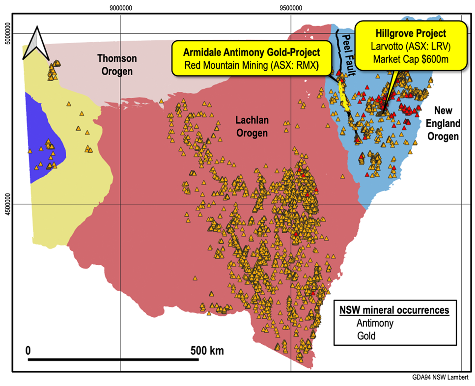
Oaky Creek and East Hills are two of several known orogenic gold and antimony mineral occurrences within the Armidale project, which have strong structural, lithological and mineralogical similarities to Larvotto’s (ASX: LRV) Hillgrove deposit to the East, which is Australia’s largest antimony-gold deposit.
Auger results reveal an extensive orogenic Antimony system at Oaky Creek South
Red Mountain’s field team collected a total of approximately 250 auger soil samples at Oaky Creek South: “Oaky S Main” (193 sample sites) and “Oaky S Minor” (45 sample sites); as well as a single line of eight samples collected across the Oaky Creek South workings (Figure 1 and Figure 2).
The Oaky South Main grid is located approximately 400m north-northwest of the historical pits and shafts at Oaky Creek South. The grid is targeted on a conventional soil sample anomaly with a peak value of 333ppm Sb1. The Oaky S Minor grid is centred ~200m southeast of the Oaky S Main Grid, targeting a soil sample located 300m north of the Oaky Creek South workings that contained 46ppm Sb and 65ppm As1. In October, Red Mountain reported2, float and in-situ rock chip samples from Oaky Creek South have returned multiple high grade results, with maximum values of 39.3% Sb and 1.09g/t Au from the Oaky South Main grid area (Figure 1 and Figure 2), while samples collected close to the historical workings have best analyses of 28.3% Sb (Figure 1) and 0.14g/t Au (Figure 2).
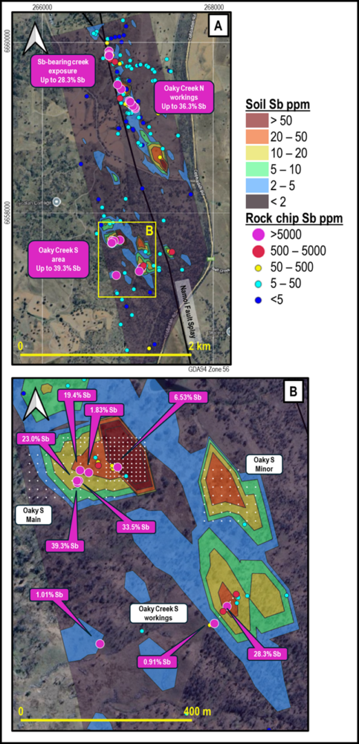

Sampling at Oaky Creek South targeted the C soil horizon and samples were collected from as deep as possible at each site. Sampling depths ranged from 10cm to 100cm (Appendix 1), with the majority of samples collected at depths between 20 and 60cm.
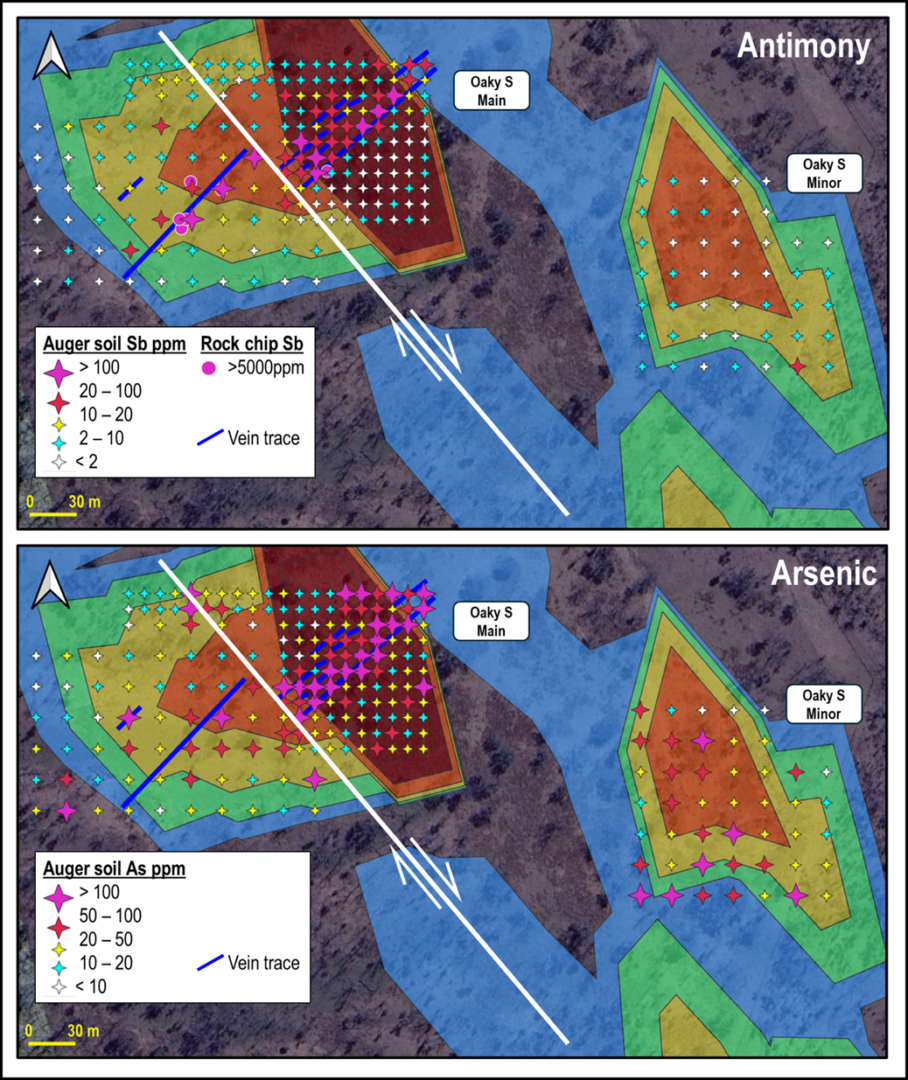
Figure 3 shows antimony and arsenic results for the Oaky S Main and Oaky S Minor grid auger soil samples.
The auger samples collected from the Oaky S Main grid define a coherent >20ppm Sb northeast-trending anomaly, up to approximately 30m in width and 200m in length, which parallels and overlaps the extent of mapped quartz-carbonate-sulfide veins. The core of the anomaly is defined by nine samples containing >100ppm Sb, with a peak value of 1,201ppm Sb (Figure 3; Appendix 1). The auger soil anomaly shows a close spatial relationship to previously reported highly anomalous rock chip samples. The anomaly and vein sets appear to be offset along an approximately NW-striking fault, which may represent a smaller splay structure off the NNW-striking major Namoi Fault splay that lies approximately 400m east of the grid (refer to Figure 1) and is thought to be the primary controlling structure and fluid conduit for the Oaky Creek antimony-gold system. The Oaky S Main grid hand auger antimony soil anomaly is open to the northeast, towards the Namoi Fault splay.
For the Oaky S Main grid, arsenic hand auger soil results closely mimic the pattern of antimony results to the northeast of the interpreted fault, which appears to essentially truncate the arsenic anomaly. The arsenic anomaly is well defined by 27 samples containing >100ppm As, with a maximum value of 1,040ppm (Appendix 1) and like the antimony anomaly is open to the northeast (Figure 3). In contrast to the antimony results, the Oaky S Minor grid is anomalous for arsenic, with six samples containing >100ppm As, with a maximum value of 257ppm (Appendix 1). The samples with anomalous and elevated (>50ppm As) arsenic have no clear structural control and are clustered around the northwest and southern edges of the grid, meaning that the anomaly is open to the northwest towards the Main grid, to the southwest, and south towards the historical workings (Figure 3).

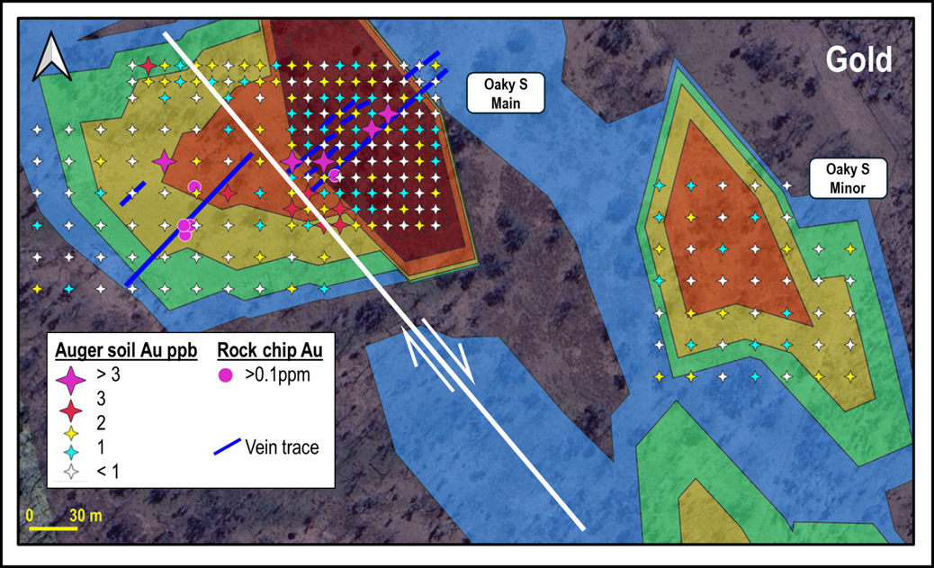
Consistent with the conventional soil results reported in June 2025[1], gold results for the hand auger sampling at both the Oaky S Main grid and Oaky S Minor grid are subdued, with the majority of samples returning assays of below the detection limit of 1ppb Au and only five samples, all from the Oaky S Main grid, containing more than 3ppb Au, with a peak value of 9ppb Au (Appendix 1). The hand auger soil samples with higher gold contents generally occur within the area defined by the >20ppm Sb anomaly on the Main Grid and are spatially associated with mapped veins and previously reported anomalous rock chip samples (Figure 4), suggesting that the gold is genetically related to the antimony mineralisation and providing further evidence supporting RMX’s exploration model that Oaky Creek represents a significant orogenic antimony-gold mineral system analogous to the Hillgrove Mine to the east, which is Australia’s largest known antimony deposit.

The identification of a large, coherent antimony-arsenic hand auger soil anomaly in the Oaky S Main grid, with associated veining and strongly anomalous rock chip samples at a distance of approximately 400m from the nearest historical workings at Oaky Creek South indicates the potential for additional discovery of previously unrecognised orogenic antimony mineralisation at Oaky Creek. Further auger sampling is planned as soon, across the following prospective target areas:
- Northeast of the Oaky S Main grid, towards the Namoi Fault.
- Across the unsampled area between the Oaky S Main grid, the Oaky S Minor grid and the Oaky S workings.
- Along the length of the 1km long soil antimony anomaly that extends south-southeast from Oaky Creek North.
Following receipt of the results of the planned December program, Red Mountain expects to be able to target the Oaky Creek prospect for drill testing.
Results across Oaky South historical workings confirm significance of Oaky S Main results
Sample (AA201), returned a significant auger soil result of 1.36% Sb, over 10x the next highest recorded value. This sample also returned the highest gold value of 14ppb.
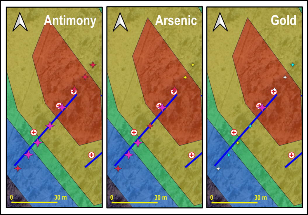
To provide a guide as to the expected auger soil response over mineralisation at Oaky Creek, RMX collected a single orientation line of eight samples across the historical antimony workings at Oaky Creek South (refer to Figure 1 and Figure 2 for location). The results of this sampling for antimony, arsenic and gold are summarised in Figure 5 and listed in Appendix 1. Gold and arsenic values are consistent with the anomalous samples collected from the Oaky S Main grid, with maximum values of 14ppb Au and 351ppm.

Encouraging initial soil results at East Hills
In September 2025, RMX collected 78 soil samples across a grid centered around a historical pit targeting antimony at East Hills in the southern portion of the tenement. Samples were collected at a 50m spacing on 100m spaced east-west oriented lines and screened to -80# in the field.
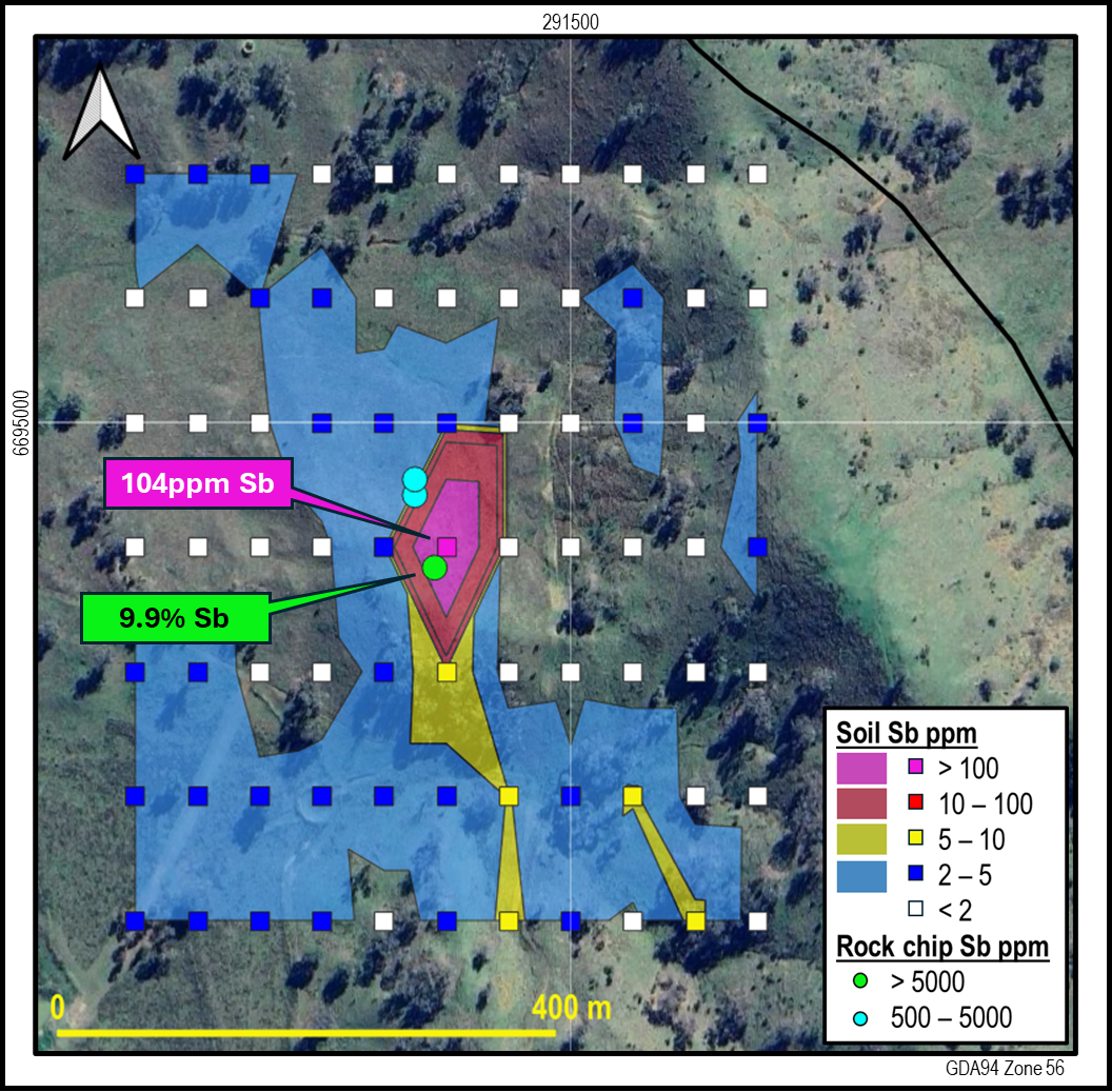
The soil antimony results define a generally NNW-trending strike-parallel anomaly, with a peak value of 104ppm Sb close to the historical workings and the previously reported[1] rock chip sample containing 9.9% Sb (Figure 6). The >5ppm Sb anomaly is open to the SSE, so further sampling in that direction may be warranted in the future.

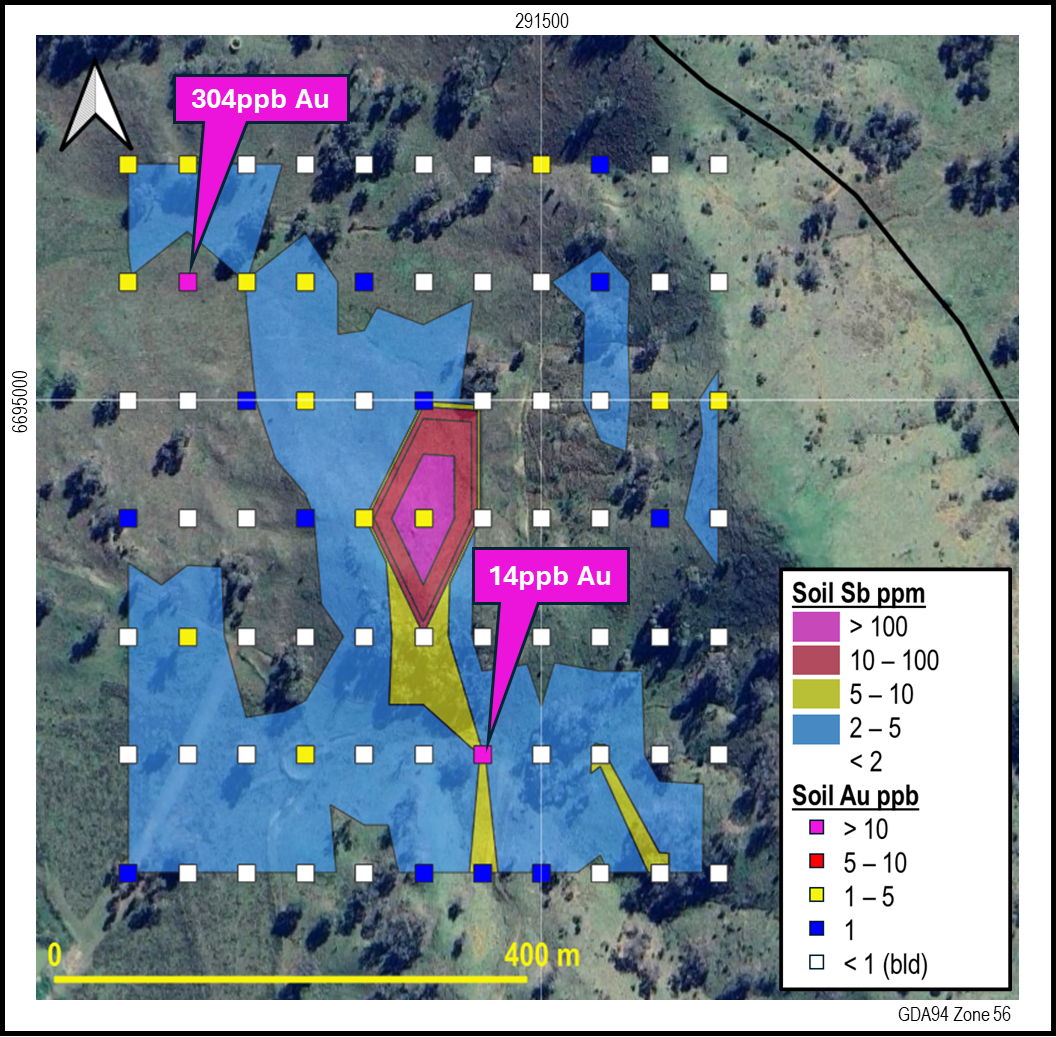
Gold in soil results from East Hills are mostly <5ppb Au, with the exception of two samples that returned values of 14ppb Au and 304ppb Au (Appendix 2; Figure 7). These two samples appear to be spatially associated with the main NNW-trending antimony anomaly, suggesting that the mineralisation at East Hills is a similar orogenic antimony-gold system to that seen at Oaky Creek. However, based on results to date the system as East Hills is a lower priority for further exploration than the Oaky Creek prospect, which appears to be a larger target.

Next steps for the Armidale Antimony-Gold Project
With highly encouraging auger soil results now received from Oaky Creek South, RMX will seek to rapidly deploy to undertake a follow-up program of auger soil and rock chip sampling over the Oaky Creek North soil anomaly to define prospective drill targets. RMX will also extend the Oaky S Main grid to the northeast to test for the extension of the currently open anomaly and sample the area between the Main Grid and the historical workings at Oaky Creek South. The Company expects that the results of this next round of sampling at Oaky Creek will enable Red Mountain to define the most promising targets for drilling in the first half of 2026.
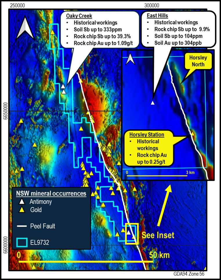
As previously reported, soil and rock chip sampling is also planned for the Horsley Station and Horsley North gold targets (Figure 8). RMX is planning further exploration across the numerous stibnite and jarosite spectral anomalies across the project, in particular those that lie adjacent to known mineralisation and/or are along the known major Peel, Namoi and Cobbadah faults.

RMX | RMXFF Armidale Antimony-Gold Project Background
Red Mountain’s 100%-owned Armidale Antimony-Gold project is located west of Australia’s largest known antimony deposit, Larvotto’s (ASX: LRV) Hillgrove deposit, which is also the 8th largest antimony deposit globally.
The New England Orogen is recognised as Australia’s premier Antimony district (Figure 9). Antimony occurs in hydrothermal quartz veins, breccias and stockworks, often with associated gold and/or tungsten mineralisation.
Red Mountain’s project extends for 85km along the western side of the Peel Fault. The Peel Fault System has recognised world-class mineral potential, with over 400 known orogenic gold and base metal mineral occurrences along its over 400km strike extent, but is underexplored, with less than 200 mostly shallow drillholes over its length, the majority of which are focused on discrete prospects.