

Red Mountain Mining (ASX:RMX) Successful Field Results at Utah Antimony Project Leads to Expansion
18 December 2025
Price Sensitive Announcement $
Highlights:
- Highly encouraging results from field program at the Utah Antimony Project supports Red Mountain’s Antimony exploration model and leads to additional expansion of claims
- Red Mountain’s Utah Antimony Project directly adjoins American Tungsten and Antimony
Ltd’s (ASX: AT4; Market Cap $152 million) Antimony Canyon Project (ACP), one of the largest and highest-grade antimony projects in the USA, with a defined conceptual Exploration Target of 12.8 to 15.6 Mt @ 0.75% to 1.5% Sb, containing between 96,000 to 234,000 tonnes of Antimony metal1 - Mapping analysis undertaken by Red Mountain strongly suggests that both the same type of host rocks and extensions of the large epithermal Antimony mineralising system targeted by AT4 at Antimony Canyon are present within Red Mountain’s project area
- Red Mountain has acquired 19 additional claims which cover the further southern extension of the major N-S trending structural corridor believed to control mineralisation at Antimony Canyon
- Satellite imagery commissioned by Red Mountain has also identified multiple similar spectral signatures to the ACP mineralisation within Red Mountain’s project area, which will be followed up by ground exploration team
- Red Mountain plans to use geophysics to map out the location of prospective structures and conductive targets beneath cover for on ground follow up work, including drill testing
Overview:
Red Mountain Mining Limited has announced highly encouraging results from its exploration program at the Utah Antimony Project in the Antimony Mining district, Utah, USA. Red Mountain has also identified and acquired a further 19 prospective claims, bringing the total for the project to 106 claims
Field Program Confirms Highly Prospective Geology and Alterations
Red Mountain’s US field team recently completed mapping of both existing claim blocks of the Company’s Utah Antimony Project.
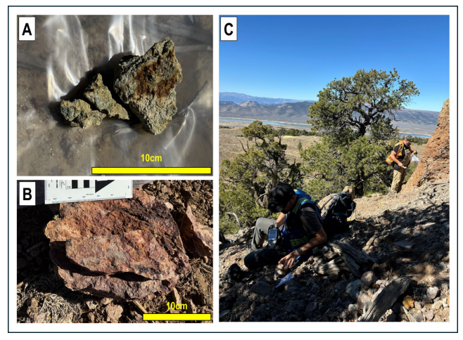
Mapping in the northern claim block confirmed the presence of similar host rocks as the principal host units for mineralisation at Antimony Canyon (Figure 1A). RMX’s field team also observed alteration consistent with the presence of significant epithermal system within the claims, including widespread pervasive argillic alteration (Figure 1C) and silicification, and more localised development of oxidised breccias (Figure 1B) and quartz vein stockworks. Alteration zones are structurally controlled by northwest trending faults, which are interpreted to represent similar Fault splays to the structures that fundamentally control hydrothermal fluid flow and high-grade antimony mineralisation at Antimony Canyon

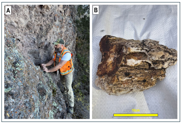
Red Mountain’s southern claims area sits higher within the Tertiary volcanic sequence than the northern claims area, with exposures of pre-Quarternary geology comprising the late Tertiary volcanic and sedimentary units that overly the basal volcaniclastic and fluvial sediments of the Flagstaff Formation (Figure 2). However, it is considered likely that The Flagstaff Formation, including the tuffaceous volcaniclastic units that host antimony mineralisation at Antimony Canyon, extend into the Company’s southern claims at relatively shallow depths. Where Tertiary volcanic basement is exposed in the southern claims area, it typically occurs as steep, fault-controlled exposures of volcanic breccias and welded tuffs showing pervasive silicification and patchy iron-oxide alteration (Figure 4A), and local zones of strong fault-controlled quartz veining (Figure 4B), which is consistent with the upper portion of an epithermal system, suggesting excellent potential for concealed antimony mineralisation at
depth.

On 25 November, AT4 announced results of a second phase of systematic rock chip and channel sampling at Antimony Canyon7 , with multiple samples returning >1% Sb, including best results of 29.4% Sb from Little Emma, 25.24% Sb from the Pluto Workings and 17.94% Sb from the Gem Mine zone.
Significantly for Red Mountain, AT4 also announced the discovery of a substantial new zone of highgrade antimony mineralisation, returning results of up to 3.59% Sb to date, and termed the “Northern Extension”, which lies approximately 1km north of the Antimony Canyon Project area (Figure 3). The Northern Extension coincides with a coherent NNW-trending CSAMT conductive anomaly and is interpreted to be controlled by splays of the Paunsaugunt Fault, highlighting the importance of these structures in controlling mineralisation and confirming the potential for significant antimony mineralisation both north and south along strike from Antimony Canyon, including into Red Mountain’s project area. The 19 new claims added to Red Mountain’s Utah Antimony Project are targeted at the further southern extension of major ~N-S trending faults that are thought to be the main control on the mineralising system at Antimony Canyon and the Northern Extension (Figure 3).
Most recently, on December 10, AT4 announced “tentative” regulatory approval of a 24 hole diamond drilling program, planned to total around 1650m, targeting the Little Emma and Gem prospects within Antimony Canyon, which drilling planned to commence before the end of December.8
Multispectral satellite data defines multiple targets within the Utah Antimony Project
During October, Red Mountain also engaged Dirt Exploration (“Dirt”) to process and analyse satellite imagery across AT4’s project area and Red Mountain’s Utah Antimony Project to firstly understand the spectral signal of the exposed mineralisation in Antimony Canyon and then identify the distribution of comparable spectral patterns within Red Mountain’s project area.
The study used the locations and antimony content of 200 published AT4 rock chip samples to generate a multispectral fingerprint of the mineralisation in Antimony Canyon. This classifier was then mapped over Red Mountain’s claims to identify potential similar targets.
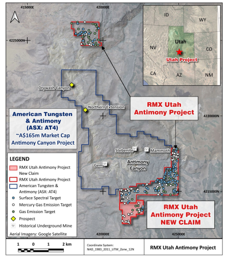

As the classifier was based on surface spectral responses, it effectively acts as a detection tool for potential outcropping mineralisation. The 100 strongest matches to the classifier within the Red Mountain claims, including the newly pegged areas, are shown as “Surface Targets” on Figures 5 and 6. These targets are mostly concentrated in the eastern portion of the southern claims area, where the underlying prospective Tertiary geology is not masked by Quaternary sediments (Refer to Figure 4)
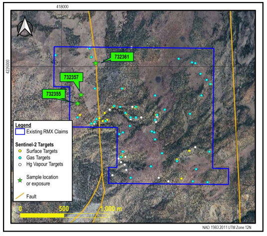

Satellite imagery can be utilised to look under cover and through vegetation by mapping spectral features associated with gases that may diffuse to the surface from shallowly to deeply buried sources. By using the AT4 rock chip sampling as a training dataset, Dirt was able to demonstrate a correlation between antimony mineralisation and elevated signals for mercury (Hg) vapour, and hydrogen (H2), methane (CH4), carbon dioxide (CO2) and radon (Rn) gas. Using this relationship, Dirt was able to map the 100 strongest “Gas Targets” across Red Mountain’s claims, which are also shown on Figures 5 and 6. These targets show a much more uniform distribution across the Utah Antimony Project, reflecting the potential for this targeting technique to “see” through cover.
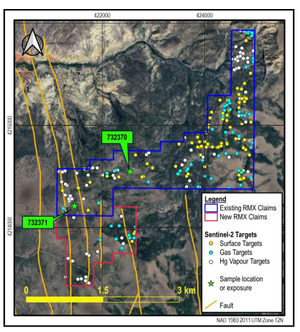

The final targeting product provided by Dirt is mercury vapour. Mercury is typically present in high concentrations in high sulfidation epithermal mineralisation and, as noted above, the mineralisation at Antimony Canyon correlates with spectral signals indicating high concentrations of mercury vapour. The element is highly volatile and mobile, and is known to migrate upward in vapour form from buried mineralisation. Mercury vapour anomalies in soil gas have successfully detected buried deposits at depths of up to 600m
Using multiple spectral features for mercury vapour that are detectable in Sentinel-2 data, Dirt mapped the 100 strongest “Hg Vapour Targets” across Red Mountain’s claims, which are also shown in Figures 5 and 6. Like the Gas Targets, the Hg Vapour Targets are present in both outcropping and covered areas across the Company’s claims, although in areas of Quarternary cover, for example in the western portion of the southern claim area and within the new claim area, they appear to be preferentially developed along and close to mapped faults (Figure 6). This relationship is consistent with the interpreted fundamental structural control on antimony mineralisation in the district
Full ASX Announcement: https://hotcopper.com.au/threads/ann-successful-program-at-utah-antimony-project-and-expansion.8945305/